
Why the world’s largest railway operator relies on a car parking map to reach notorious drivers
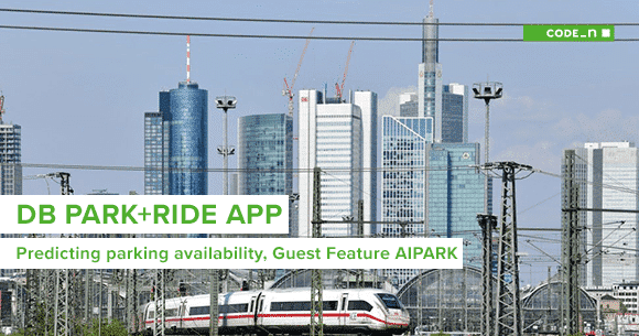 Deutsche Bahn (DB) – a 320,000 employee imperium and the world’s largest railway operator – just launched a new information service aiming at car drivers. While this may sound counterintuitive, there is much reasoning behind it.
In the aftermath of a vigorous Diesel scandal that kept the Automotive industry and the international press busy for years, multiple cities in Germany took urban air quality on their agenda and started introducing driving bans for a range of car models. Germany-wide, approximately 5.7 Mio cars are affected. This becomes reality although the German government promised 1 Bil. Euro for actions that lead to clean city air in 2017, initially trying to avoid diesel bans. Diesel bans are here and will be extended throughout 2019, driven by court orders forcing cities to react despite the protests of the general public.
What options do diesel drivers have now?
While the political situation still remains passionately discussed, travelers need immediate alternatives to their private vehicles when going into the city. But what are these?
Just having lived through the year of the scooter, some might think that all the new mobility offerings might be a practicle way to stay mobile. Ride-hailing, car sharing and others are extremely convenient to get from A to B and allow to get a ride with just a click of a button. However, these services are only happening inside the inner city borders and barely reach nearby suburbs.
In Germany, a vast 70% majority of people lives in suburban areas and little villages. These people are excluded from all the mobility innovation happening inside the metropolitain areas. Also traditional public transport, scheduled bus lines and regional trains, struggle with deficit-making offers on countryside that cover only 60% of their costs in average. In their daily lives, all these people are still dependend on their privately-owned car — simply because they have no better option.
But wait – what about Park+Ride?
Park+Ride is decade-old concept meant to promote public transport and to keep cars out of the city center. It is based on investment in infrastructure: Building large parking facilities close to public transport stations at the city borders. In Germany, thousands of these parking lots have been built after the first Park+Ride sign was introduced 47 years ago, back in 1972. One could think that so much time has passed, that the initial problem must have been surely solved.
So, why are we still seeing cohorts of motorists congesting arterial roads day by day? It appears that Park+Ride fails to deliver on its original promise.
Park+Ride sign, first introduced 1972
Today, multimodal mobility is hard
When do travelers actually use Park+Ride? The chart below gives an overview on the travel circumstances that lead people to choose Park+Ride or going solely by car. In this relative comparison, the fact that the absolute number of car rides is much higher than the number of Park+Ride rides is neglected.
Two things are interesting here:
- Only commuters appear to have adopted Park+Ride offerings
- Especially for shopping & leisure, car-only is dominating and Park+Ride only plays a minor role (while this category is responsible for the highest share of private car usage in general)

Research Institute for Regional and Urban Development North Rine-Westphalia 1996 / Umweltbundesamt 2015
What makes Park+Ride so unalluring?
The reason why no one really uses Park+Ride for trips other than commuters is simple: The trip to and from work remains the same every day. Commuters know where to park, at what time to come to save a spot, how long it takes to walk to the tracks and which trains to catch. After quite some intial research and planning effort, commuters find their individual route because they have been trying and testing over time.
The picture looks entirely different when considering trips for shopping & leisure purposes: If one decides to use Park+Ride for their way downtown, the problem of figuring out how to actually get there becomes indefinitely complex. Before even leaving the house, one needs to figure out:
- where they will find an open (and in the best case free) parking spot
- which train station to head to (this also interferes with the first)
- planning out timings (way to parking lot, time for finding a spot, walking time to the right track, departure times …)
- how to decide: driving closer to the city (in favor of lower ticket fares / cheaper price zones) or parking outside (for better parking options and saving on gas)
- which train to choose and finding the best ticket option
To wrap it up: Park+Ride is way too difficult to be a serious alternative to the private car for trips at varying times, locations and contexts.
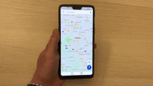
User desperately trying to find a Park+Ride route in Stuttgart with Google Maps
Including the private car in the multimodal travel itinerary
With this knowledge in mind, DB quickly realized that the attractiveness of Park+Ride can be increased by connecting the dots and providing the user with all relevant information in one place.
They (obviously) already had data on their connections and a way to present it in their app in form of a simple itinerary, their users had adopted. They required two missing pieces of the puzzle in order to be able to build the new service:
- Structured data on parking POIs close to their train stations (not necessarily only off-street / managed facilities)
- An advanced routing algorithm that connects every aspect of the journey: Driving, parking, walking and public transport.
We at AIPARK provided DB with a vast set of information regarding parking options for the greater Stuttgart area served by our parking APIs. This included everything that travelers are interested in: Opening hours, prices and as a debut to the public transport market – a live map of open parking spots covering the whole region.
Together with our partner Here Technologies, we built the DB Park+Ride apps for Android and iOS to include people’s private car into their personal travel itinerary. Taking away the burden of complexity when planning Park+Ride, the concept becomes a valid alternative for people in suburbs and villages facing diesel ban reality.
The apps include a fully-fledged turn-by-turn navigation for the drive to the station and filter preferred parking options. Below a quick glimpse:
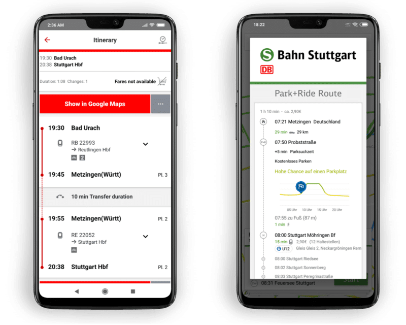
Left: Standard DB travel itinerary; Right: Custom Park+Ride itinerary including live parking space availability at arrival
Results
The DB Park+Ride apps went live in late December 2018 in the Stuttgart region, seen by many as the epicenter of the diesel ban discussion.
The feedback we received clearly proved that parking is a key aspect in multimodal mobility and real-time information on parking availability the key to success in making Park+Ride offerings more attractive.
Here are some first statistics from about 200 user feedback submissions we received so far:
- 87% would recommend the service to their friends
- 85% want to the service to be extended in the future
- The average user opens the app 3 times per week to request Park+Ride routes.
- The app is mostly used for leisure (on Fridays & Saturdays), proving our initial intention to increase Park+Ride use for other purposes than commuting
The article was originally published on www.aipark.io on January 15, 2019.


Write a comment